How to Retrieve and Use ArcGis data
I was tasked with a unique project: predicting home property damage using hail‑swath data so the company can better allocate funds and resources after major storms. Here are the key challenges I faced:
- The claims department had no prior experience working with hail data. They did have an ArcGIS Server I could use to access geospatial layers, but there was no existing python codebase or workflow to build on.
- I needed a reliable way to connect the geospatial hail data with claim records so I could create training data for modeling and also support future inference. This required figuring out how to geocode claim locations, perform spatial joins, and ensure the resulting dataset was accurate and repeatable.
 In this case, I have 3 persons and they have the address info listed in table. Now we want to see CDC’s three actions, insert, update, and delete. We design an incoming table, test_cdc_2. So we can see these 3 actions.
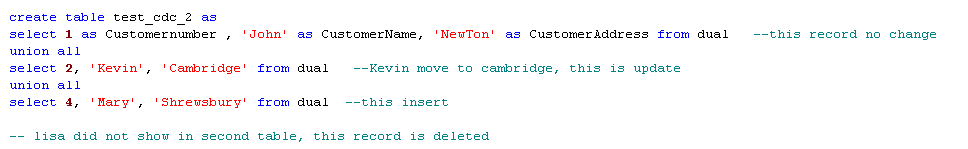 In this table, you can see John keeps the same location, Kevin changed location to Cambridge, Lisa is not customer anymore. But we have new customer Mary. So John keep the same, Kevin will need to be updated, Lisa will be deleted and Mary will be inserted.
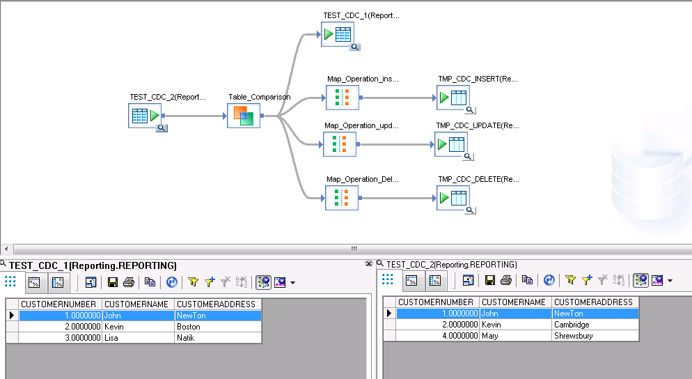
I created data service job like the follows, what is displayed is data flow part.
In this table, you can see John keeps the same location, Kevin changed location to Cambridge, Lisa is not customer anymore. But we have new customer Mary. So John keep the same, Kevin will need to be updated, Lisa will be deleted and Mary will be inserted.
I created data service job like the follows, what is displayed is data flow part.